Chapter one
Canada facts
-
Alert Nunavut is where radar systems to protect Canada is.
-
2nd largest country by area at 9,992,000km²
-
Population density: 3.72 people per km²
-
2022 population 38m
-
Largest fresh water area
-
Canada is 2nd in terms of resources per Capita, Australia is first
-
Longest non militarized border (south 8891km, Alaska 2475km)
-
Largest coastline in the world
-
An escarpment is when the elevation sharply changes
What is geography
-
Geography is a science that deals with Earth’s surface.
-
People who study geography are called geographers.
-
Geographers are interested in Earth’s physical features,
such as mountains, deserts, rivers, and oceans. -
They are also interested in the ways that people affect and are affected by the natural world. This is our focus for grade 9
Capitols and lat/long
-
Whitehorse, Yukon, 61°N 135°W
-
Yellowknife, Northwest Territories 62.5°N 114°W
-
Iqaluit, Nunavut 64°N 68.5°W
-
Victoria, British Columbia 48° N, 123° W
-
Edmonton, Alberta 53.5° N, 113° W
-
Regina, Saskatchewan 53°N 116°W
-
Winnipeg, Manitoba 48°N 97°W
-
Toronto, Ontario 43.6°N 79°W
-
Quebec City, Quebec 47°N, 71°W
-
Saint John’s, Newfoundland & Labrador 48°N, 53°W
-
Charlottentown, Prince Edward island 46°N 63°W
-
Fredericton, New Brunswick 46°N, 66.6°W
-
Halifax, Nova Scotia 45°N 64°W
Random stuff
Big tall sharp peaks In Canada means the Rockies aka British Columbia
Banff national park is in Alberta and 4th oldest in the world
Most capitals are in the lower (southern) part of the province
Chapter 2 - Maps, mapping and scale.
What is the value of maps?
- Knowledge and information representation
- Record and store information (property, utilities, infrastructure..)
- Visual and spatial representation of information - convey info that is difficult to express verbally - used as a spatial tool (e.g propaganda)
- Map construction
What is a map?
-
A two dimensional representation of an area features drawn in a flat surface
Types of maps:
-
Thematic - usually one specific thing about the area
A thematic map is a type of map that portrays the geographic pattern of a particular subject matter in a geographic area. This usually involves the use of map symbols to visualize selected properties of geographic features that are not naturally visible
-
Topographic
To show elevation data.
Basic map features
-
Title
-
Political
Shows the different levels of government
-
Legend
-
Scale
Measurement on a map that represents an actual distance on the Earth’s surface.
Shows ratio of distance between two points on a map and actual distance between two corresponding points on the earth Map Scale Map Distance Ground Distance
Large vs small scale:
- Large: lots of detail e.g. hiking, military, residential planning (1:150,000 of less)
- Small: small amount of detail to. Large areas (e.G. Political) (1:150,000 or more)
Map projections
Method used to transfer features onto a map (Man projections with adv and disadv)
-
Equal-area: correct relative size of countries avoiding major distortion
-
Mercator: true compass bearings, but distorts distance and size of land
-
Winkel Tripel: balanced between size and shape
-
Map scales
Measurement on a map that represents an actual distance on the Earth’s surface.
Shows ratio of distance between two points on a map and actual distance between two
corresponding points on the earth
Map Scale Map Distance Ground Distance
Ways to identify a location on a map
-
Alphanumeric grid
The alphanumeric grid uses alphanumeric values to identify grids in a map, it’s often used in road maps.
Eastings then Northings.
-
Latitude + longitude
N and S lines in either sides of the equator and E and W lines on either side of the prime meridian. (Canada is in the northern and western hemispheres.)
Uses coordinates to locate places (degrees, minutes, seconds)
The lines are called meridians.
-
Military grid.
Made up of blue lines on topographic maps… Used to locate features each is given a 2 digit number from 01-99
(lower number always first) and don’t put the decimal
FORMAT: [EASTING² 1] [NORTHINGS² ¹]
-
Vertical lines are called Eastings
-
Horizontal lines are called Northings
-
Eastings are always first then Northings
-
Timezones
Important
On a map a half clock signifies a half timezone
-
Canada’s timezones
Each time zones has a name (W to E): Pacific Mountain Central Eastern Atlantic Newfoundland
Pacific: Used in British Columbia and Yukon
Mountain: Used in Alberta and some parts of Nunavut
Central: Used in Saskatchewan, Manitoba, and some parts of Nunavut
Eastern: Used in Ontario and Quebec and in most parts of Nunavut
Atlantic: Used in New Brunswick, Nova Scotia, and PEI
Newfoundland: Used in Newfoundland
As you go to the West from Atlantic onwards, you remove one hour however from Newfoundland to Atlantic it’s 30 minutes.
The earth rotates in a East direction and therefore the sun rises in the East and sets in the West
The earth rotates through 15 degrees per hour
-
How do we calculate timezone.
- There are 24 timezones around the world one for every hour of the day
- Generally, each is 15 degrees of longitude wide. There are exceptions in the cases of smaller countries in where you can have the entire country be a timezone to simplify it for the citizens.
- Time changes moving EAST or WEST past times zones - not moving north or south.
-
Why do we have them
- The earth rotates so we want time to be consistent
- Helps people keep time in an organized way
- Allows modern transportation to keep accurate schedules (arrivals and departures esp. for long distance travels)
Chapter 11 ~ Geology
What is geology: study of Earth's physical composition
Spheres of this planet
-
lithosphere,
- hydrosphere,
- atmosphere
- anthrosphere
- biosphere
Different types of crusts
-
Continental
Thick (10-70km)
Buoyant (less dense then oceanic)
Mostly old
-
Oceanic
Thin (~7km)
Dense (sinks under Continental crust)
Younger
Rock cycles
Ways to erode
-
Pressure (compression)
-
Heating or melting
-
Erosion
-
Freezing and warming
Types of rocks
- Igneous (magma based) (crystals too)
- Sedimentary (congealed | over time with pressure) also usually created under water.
- Metamorphic (cooked and squeezed under great heat/pressure with chemicals) (often found at plate boundaries)
Ways for land to change
- Land/Mountains built up by Tectonic Forces
- Volcanoes
- Moving plates
- Deposition, etc
- Land worn away by Weathering and Erosion
- Rain, rivers, oceans
- Wind, gravity
- Glaciers, etc
Geologic time scale
The history of how the Earth has changed from ~4.6b years ago to nowEarths history can be broken into 4-5 parts
-
Anthropocene? (~200y-present (human impact)
- Modern human terra forming including, massive deforestation, mega cities and pollution.
-
Cenozoic (66m - 200y ago )
- More folding and faulting (mountain building)
- Volcanic activity (surface and sea floor)
- THE AGE OF MAMMALS (incl. Humans)
- ~20,000 years ago glaciers shaped the land (also smoothed mountains)
-
Mesozoic (245-66mya)
- Dino’s alive now
- Formation of fuel deposits in sedentary rock
-
Paleozoic (570-245m years ago)
- More mountain building along with the erosion of the Canadian shields
- Erosion produces sediments
- Sediments moved by gravity, wind, and water and deposited around it.
-
Precambrian (4.6b-570m years ago)
-
Many cycles of building and erosion
-
Canadian shield was created then
-
Primitive life forms now. (Single celled plants and animals
-
Theory of continental drift vs theory of plate tectonics
~220 m.y.a there was one supercontinent Pangea then slowly overtime the continents drifted apart over 200 million years to the current Continental locations-
Theory of Continental drift
- Developed Early 1900’s
- Proof one: visually south America and Africa fit together like a puzzle
- Proof two: fossils of various varieties are found across continents (meaning they must have been attached in the past)
- Proof three: mountains across the Atlantic had the same stratifications (sedimentary layers) and structure. (Appalachian Mnts and Caledonian Mnts)
- Proof four: evidence that ice sheets covered the southern tips of SA, Africa, Australia & India. Glacial ice can’t exist today in those continents so they must have existed in the past.
-
Theory of plate tectonics
- Developed in 1960s
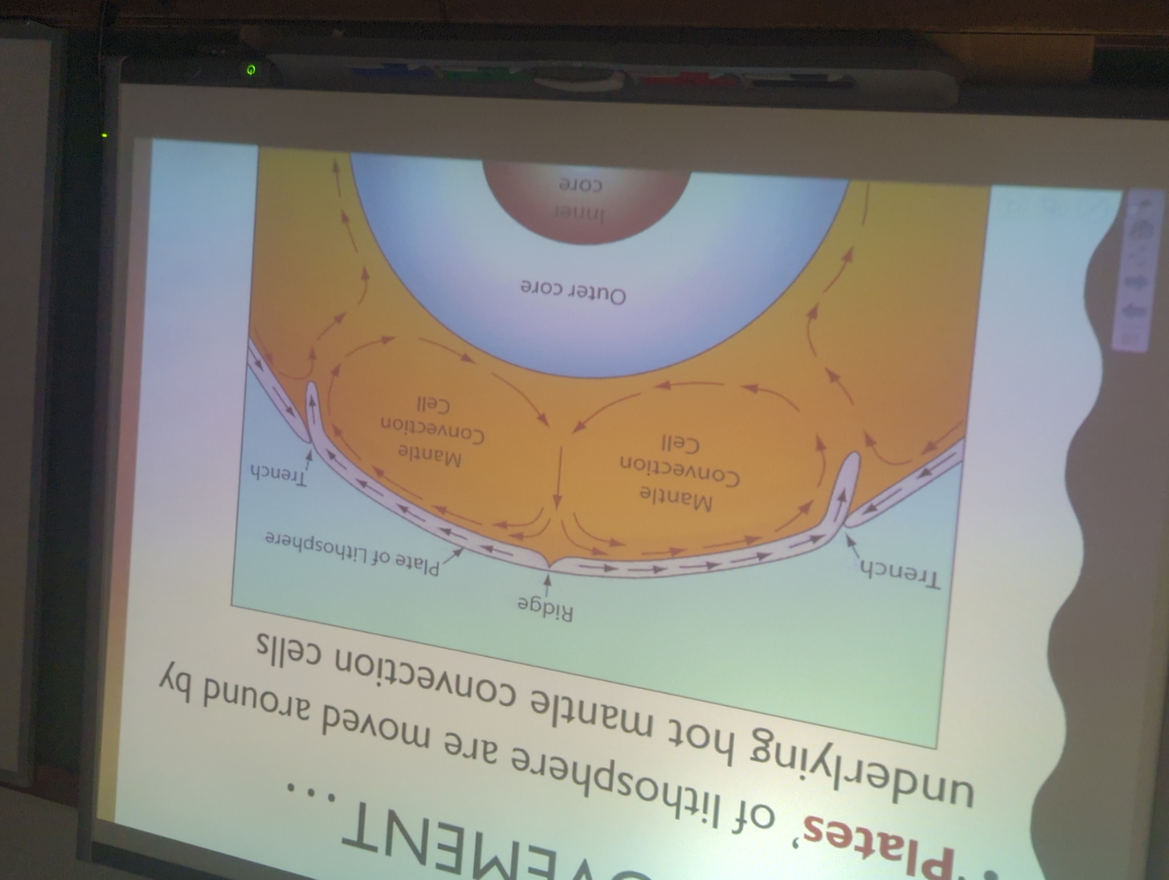
- Bases it’s logic off of mantle convection. Mantle convection is when the core heats up rock then that rock rises up and cools so then it falls back down and the cycle repeats.

Convection currents: the heat of the core heats up rock which then rises into the mantle but the mantle is cooler so it cools and falls back to the core. (Aka the cycle of rock in the earth) -
Chapter 12 ~ landform regions of Canada

-
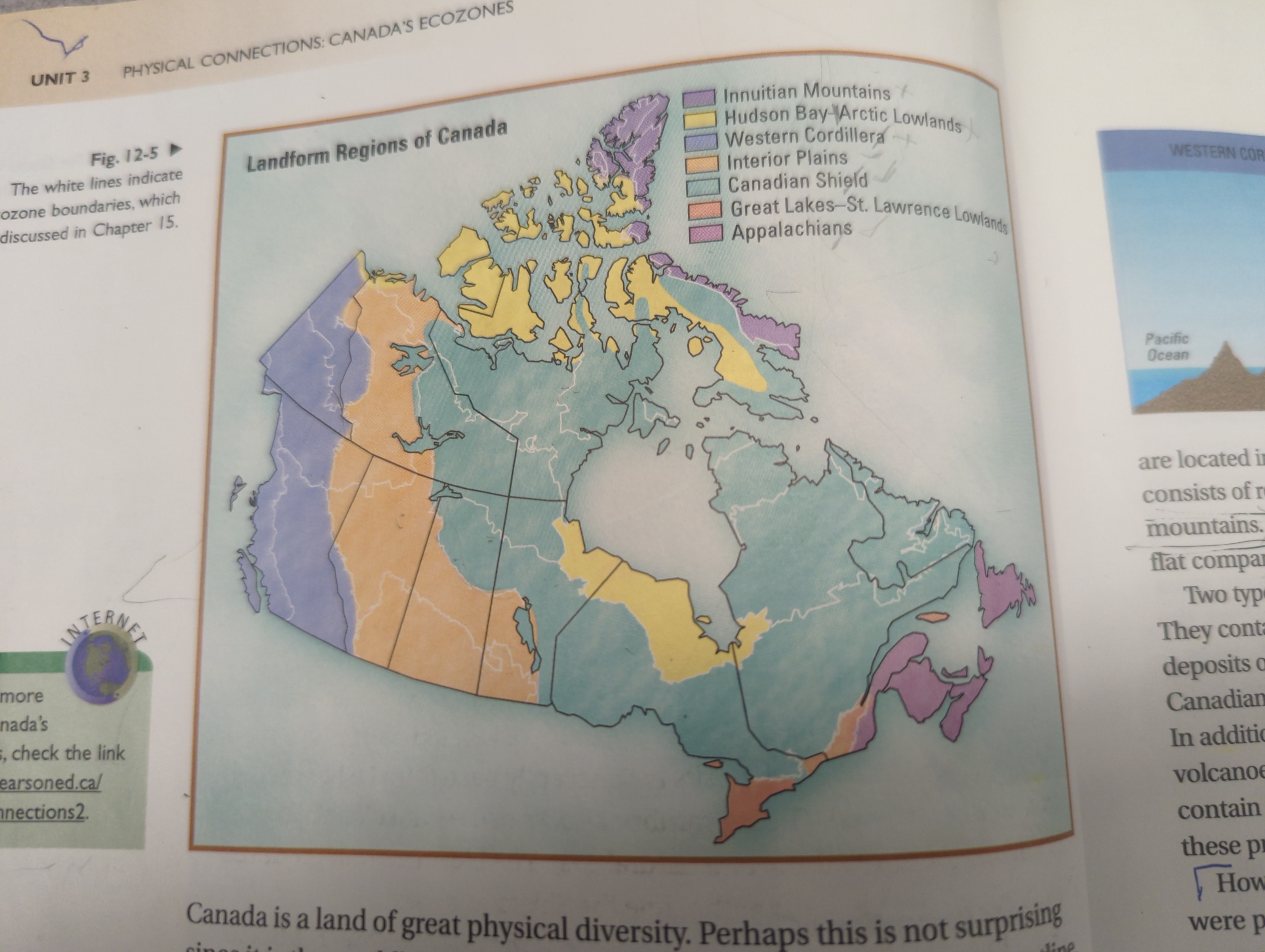
Arctic Lowlands.
-
Igneous, sedimentary & metaphoric
-
Lots of mines
-
Very wet
-
Polar bears
-
Fishing, trapping and mining.
-
-
Appalachian mntn highlands.
- 2.5 b.y.o so tons of errossion
- Only 2% of CA’s area
- Rolling landscape (bc of errossion)
- Fishing, oil and gas (in water), tourism
- Sedimentary with a big of metamorphic rock
-
innuitian mntns ( arctic highlands)
Arctic Highlands
- Sedimentary rock (via folding mountains)
- Short summers
-
Great lake st Lawrence lowlands
- Sedimentary rock
- Where we live
- In Canada, 2/3s of the population lives in this.
- Farming (Tobacco, peaches…), Logistics
- Lots of urbanization
- Formed by glaciation 9k years ago
-
The Canadian Shield (plateau)
- Loads of mining (gold, silver, nickel), forestry
- Tons of igneous and metamorphic rock
- Heavily eroded
- Relatively flat with smooth rocky hils
- Hydroelectric electricity generation
-
Interior planes
- In Alberta, Saskatchewan & Manitoba
- Sedimentary rock
- Agricultural hub
- Flat landscape perfect for farming
- Contains oil and gas. Mostly in tar sands)
- Ranching (cattle, sheep)
-
Western cordillera
-
Very young (65myo)
-
All types of rock.
-
LOADS of tourism as it’s stunning, also mining (gold, zinc, copper..) & logging
-
Rocky mountains are the eastern bounties
- Contains fossils
- Columbia mtns (sedimentary with bits of metamorphic)
-
Along the w. Coast of N. America
-
Peaks are sharp!
-
The rock is a result of the volcanic activity
-
Surface waters In Canada
The five main drainage basins are..
- Hudson bay
- Arctic ocean
- Atlantic ocean
- Pacific ocean
- Gulf of Mexico
-
-
Chapter 13 ~ climate
Things that affect climate
-
L - Latitude
- Canada extends from 41°N to 83°N
- Each degree is 111km
-
O - Ocean currents
- a continuous, directed movement of water.
- Relative temperature of current - compared to surrounding waters
- Forces acting on currents: Coriolis effect, breaking waves, tempature
- Ocean currents transfer tempature characteristics to the air above.
- When warm and cold currents meet, it’s often damp and foggy. (E.g. Labrador current and gulf stream forms for)
-
W - Wind & air masses
-
Air mass> [!important]
M = maritime (created over the ocean and has lots of moisture)
C = continental (created over land so it's Dry- Large volume of air
- Takes on the climate conditions where it’s formed.
- Transfers those conditions to places it travels.
- Warmer air masses generally have a higher moisture content (cold can’t keep the water as a gas bc it will freeze)
-
Wind
- Wind is created when air masses move
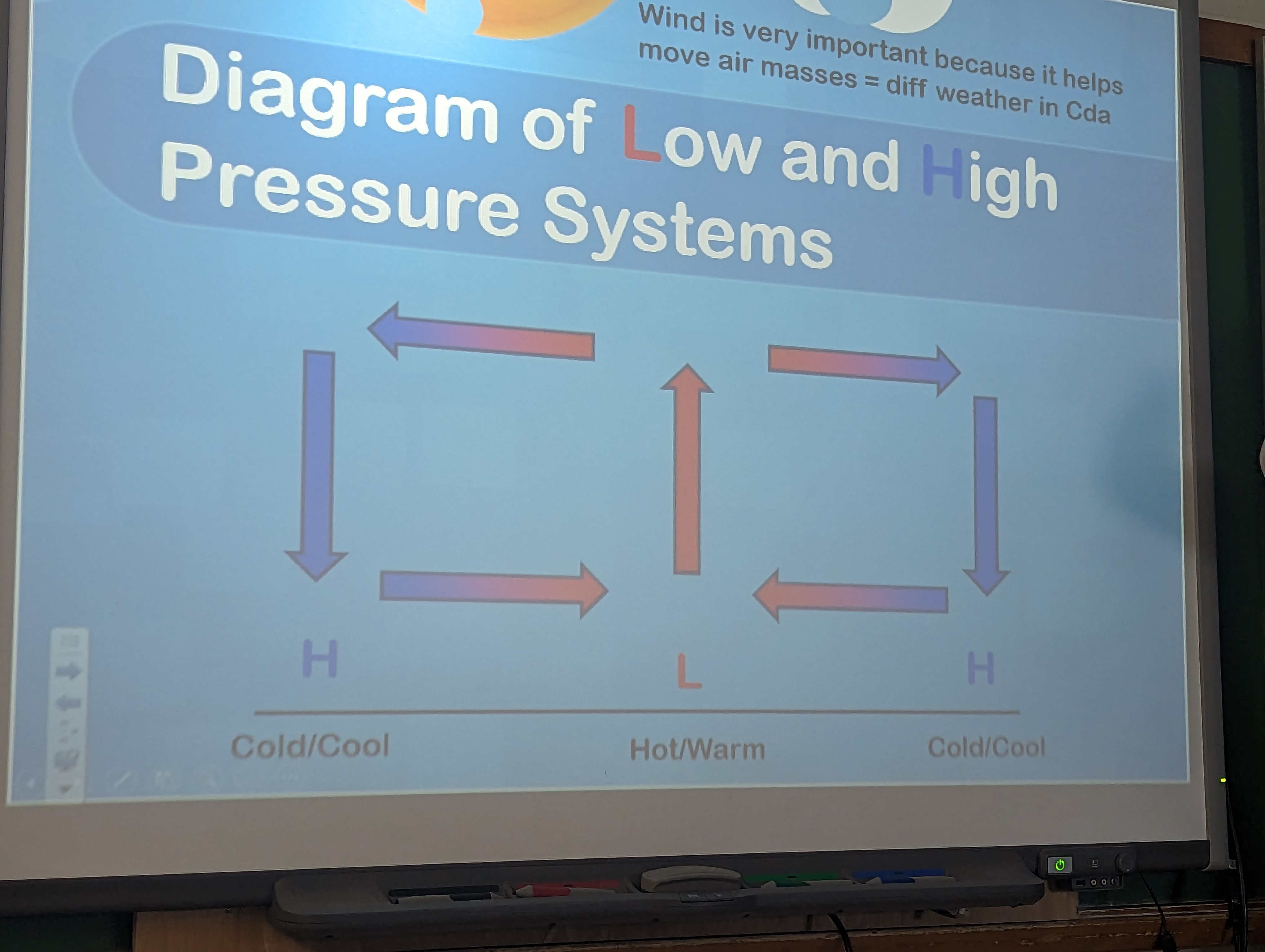
- Air moves when there is a difference in air pressure
- Jet streams move at 3-500km/h and at an altitude of 20-25km
- The clash of warm and cold air masses along the polar front stream produces weather events (snow, rain, violent thunderstorms, tornados…)
Pressure
When places are heated to diff temps
-
Where earth is hot, air will warm. Warm air rises and create a low pressure region.
-
In the upper atmosphere, air cooler and starts to fall, creating a high pressure region

-
-
E - Elevation
- Below condensation
- Rate of change 1°/100m
- Above condensation
- Rate of change 0.6°/100m
- Below condensation
-
R - Relief and other predication
-
Relief (The shape of the land )
-
When moist air comes across a barrier (eg. Mtns), it rises.
-
-
Relief precipitation
-
Cyclonic precipitation
- Lighter, warmer, moist air forced to rise above colder, denser air.
-
Conventional
- Violent short lived storms, occur in afternoon or evening of a hot day.
- Cause: Summer heat warms ground
- Up and downdrafts create huge water drops
- Only precipitates when air is moist
-
-
Near water
-
Continental region: any area away from oceans
-
Maritime region: any area near oceans
-
The temperature is more consistent because of the moderating effect.
-
Near water
Polar regions: colder as the sun’s energy is spread over a larger area
Equatorial regions: warmer as the sun’s energy is more concentrated
Climate vs weather
-
Climate: long term patterns which stay in a region
-
Weather: day to day state of the atmosphere (temperature, moisture, precipitation, wind, pressure, ect) in an area
-
Tests
- Maritime = total precipitation ≥ 1000mm
- Maritime = temp range ≤ 25C
-
-
-
Chapter 14 ~ soil
Natural vegetation
Plants that grow without human interference- Moisture, heat and particular types of soil determine what will grow
- Layers of soil
-
Humus
-
Rich and dark color
-
-
- 7 natural vegetation regions in Canada
- Tundra
- Located above tree line (no tree’s)
- Harsh cold and dry climate
- Permafrost - ground that does not completely thaw in summer
- Boreal and taiga forest
- Located below treeline
- Largest vegetarian region in Canada
- Taiga - northern part of region
- Less dense vegetation
- Boreal - southern part of region
- More dense vegetation
- Coniferous trees grow here.
- Mixed forest
- Both tree types
- Transition zone between Boreal and taiga forests, and deciduous forest
- Lots of rain
- Abundant amount of humus
- Deciduous forest
- Small region
- Long and hot summers
- Mild winters
- Plentiful precipitation
- Most fertile soils of eastern Canada
- Lots of urbanization
- Grasslands
- Very dry climate
- Sod mat - intertwined root system that absorbs moisture and holds soil in place
- Located next to western cordillera aka the interior planes
- Subregions
- Short grass prairie
- Long grass prairie
- Parkland
- Cordilleran vegetation
- Along side mountains
- Wise range of temperatures, precipitation, soil types and elevation
- Large variety of natural vegetation
- West coast Forest
- Located in the west coast
- Temperate rainforest (RAINFOREST!)
- Mild temperatures
- Heavy rainfall
- Large trees (10ft+ diam)
- Tundra
- Tree types
-
Deciduous
-
Coniferous
-
-
Chapter 18 ~ Immigration
Multiculturalism
-
Canada is made of 97% immigrants
-
Immigrants are encouraged to keep their culture while integrating
Immigration history
Canada has had 400 years of immigration. This is a key factor to our cultural diversity
Immigration trends
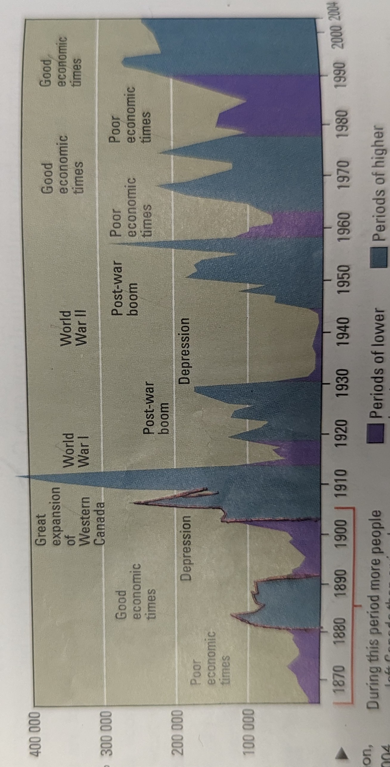
- 1840s ~ Irish settlers (potato famine)
- 1905-14 ~ tons of new people from eastern european/usa ( free land in prairies to new immigrants so they could farm )
- 1915-19 ~ low immigration (WW1)
- 1930-45 ~ low immigration (great depression/WW2 and drought in Canada)
- 1947-60 ~ Italian’s migrating ( seeking political & economic stability)
- 1950s ~ immigrants seeking stability from regions effected from the cold war. / Post war boom
- 1956 ~ Hungarian refugees (fleeing from …
- 1967 ~ gov’t appends the immigration policy to allow skilled workers and business immigrants (Pierre Trudeau)
- 1968-75 ~ tons of refugees
- 1979-97 ~ lots of southeast Asian including a lot of people from Hong Kong migrate ( seeking stability/political stability from Communist China)
- 1980-03 ~ many afghans going to Canada ( seeking a safe haven from issues in their country)
- 2022 ~ 1m new immigrants ( backlog from pandemic )
Why do people come
- Seeking safety/asylum
- When economy is good, immigration is good
Where to do they go
- Toronto/Montreal/Vancouver
- Ontario / British Columbia/ Quebec/ Alberta
Three types of immigrants
- Economic + family
- Skilled workers
- Business immigrants
- Family
- Family of Canadian citizens
- Must have sponsor and support if needed
- Refugees
- Fearing persecution/cruel/inhumane conditions
- Trying to get away from a struggle
Immigration point system
- 24 - if you know English/French
- 21 - 4 years of working
- 10 - 21-49 Age.
-
-

-
-
Culminating
Hand it in a pile. Good copy on top notes on bottom DUE JUNE 8TH
Fmt: APA needs to be 2.5-3pages BEFORE images
Min 4 sources :> 825
References are sorted by last name alphabetically
Potentially add title (title, GCG, date), add opening sentence
PUT CITATIONS INSIDE OF SENTENCE: PUNCTUATION GOES AFTER!
- Ideas
- Canada’s falling biodiversity (focus on polar bears)
- Something about how people are not interacting with nature as much anymore (or a younger generation)
- HOPEFULLY SOMETHING About Space
- Naturel disasters
- Pollution in st Lawrence lowlands
- The falling types of trees in the mixedwood (x)
- The increasing housing crisis in Canada how how it will happen increase in the future. (Focus on Toronto) / (have a focus on the 500k new Canadians per year.)
- Violence and untrust in relation to the TTC and it’s effects.
- Title: what is going on with the TTC (issues with the TTC)
- Violence
- Slow speeds
- Mechanical issues
- Why it’s always overcrowding (talk about urban planning)
- Questions
- Why is it happening
- What can we do about it.
- What are the effects of these issues.
- Title: what is going on with the TTC (issues with the TTC)
What where, why there, why care? Those are the questions that can be asked about most places/things. Right now what
P61/62 for the guide and the process is APA also 45 for apa
- Ideas
-
Bailey exam
- governmental contracts
- Talk about how city controls the water
- Talk about how water allows all others to flow.
public utilites
Homework
Alphanumeric grid. (Questions 1-10 p. 32.)
-
It means that there was an OPP detachment there and a first aid station. And highway 661
-
N13
-
Lake nipissing
-
a) cobalt b) northeast
-
Sundridge is larger
-
N13, N14 N15, N16, M15
-
Killarney 013 Local airports, Sunbridge 015 Local airport, Nickel N14 Major airport, C.E.B North Bay n15 Major airport, Earlton L15 Sec. Airport.
-
a) the number in km next to the road and also the scale b) 72km. 67 Km. 38 km.
-
New liskard
-
Nickel, copper